 The Neches River
Its History and Culture . . .
The Neches River has been a major part of the history and culture of Southeast Texas. Native Americans and later European Americans have found their food, shelter, and other lifeŁ-sustaining essentials from the River for thousands of years.
Originating springs start at an elevation 545 feet above sea level just east of Colfax in Van Zandt County. From here, 416 miles of winding river flows to the Gulf Coast It has a drainage area of approximately 10,011 square miles. (An analysis..., 1974). The Neches River gained its name from the Spanish who took the name from the Caddo word "Nachawi," meaning "wood of the bow," bois d'arc trees, that grew along its banks (Donovan, 2007).
The Caddo Indians reach the Neches about A.D. 780, bringing the American Indian population to its peak. When Hernando de Soto's expedition entered Texas looking for a route to Mexico in 1542, Spaniards were greeted with the word Tejas, meaning "friend." The Spanish concluded that was what the natives called themselves and therefore, called all of the land east of the Trinity River Tejas-later Texas (Donovan, 2007).
The first European settlement in Texas, the mission San Francisco de los Tejas, was build in 1690 near the mouth of San Pedro Creek where today's community of Weches exists. Spanish attempts to establish a permanent colony among the Neches Caddo failed, but in 1779 Antonio Gil Y' Barbo led a group of settlers back to the Nacogdoches and that settlement claims to be the oldest town in Texas (Donovan, 2007).
Twenty years following the Nacogdoches settlement, other Native American tribes began moving into the Caddo lands. Most were Cherokee, but Choctaw, Kickapoo, Shawnee, and Cherokee lived in these lands peacefully for at least 35 years. Mirabeau B. Lamar broke this peaceful existence when as the second President of the Republic of Texas decided to purge all Indians to make way for the Anglo settlers (Donovan, 2007).
Arriving Cherokees through 1820 received permission from the Spanish to settle on the land. Bureaucracy with Europe presented title transfer before the Mexican revolted and overthrew their Spanish controllers. Sam Houston, John Forbes and John Cameron hoped to keep the Indians neutral in the war with Mexico. A Treaty was signed in February, 1836, that gave the Cherokees and related tribes the title to all the lands between the Angelina and Sabine Rivers. Unfortunately, Santa Anna was defeated quickly at San Jacinto, and the Texas Senate did not ratify the treaty.
Tevis
Americans responded to a drive for expansion and moved to unclaimed western territories. Noah Tevis, a Scotsman born in Maryland in 1782, traveled to Louisiana where he married Nancy Nixon of French descent. They had seven children before they traveled the Opelousas Train in 1824 to settle on a wooded bluff on the west bank of the Neches River.
On that bluff they build a two-room log cabin with dog trot and mud chimney. Tevis cleared a twenty-acre field with com and sweet potatoes and planted peach and fig trees. He built a cattle pen for the domestic animals that he brought along with some wild cattle from the prairies. Their eight child was born here as probably the first while baby born in the Sabine-Neches area. The Tevis farm and the community that grew up around it became known as Tevis Bluff or the Neches River Settlement. In 1835, Nosh Tevis received formal title to this land of 2214 acres on the western margin of the Neches River (Rienstra and Walker, 2003).
Families started moving into the area settling on parcels of land to the north and south of Tevis Bluff. Notable was Joseph Grigsby who found a spot a few miles downriver of the Neches Community. There he established a plantation worked by several slaves. The announcement that follows appeared in the October 26, 1835, issue of the Telegraph and Texas Register in San Felipe de Austin (Rienstra and Walker, 2003):
We are informed that a town has lately been laid out on the tidewater of the River Neches, at a place known as Tevis Bluff, thirty miles from Sabine Bay. Its situation is said to be one of the most delightful in Texas and it has already commenced improving at a rapid rate. It is spoken of as a town which promises to be one of considerable importance. It has received the name of Beaumont, which, from the description of the place, strikes our fancy as very appropriate.
Plans for the development of the town were halted by the oncoming Texas Revolution. Beaumont did form its own military company and later send 28 men to join the Third Company Infantry, Second Regiment Texas Volunteers. General Sam Houston's retreat eastward sent the wrong message to many Texans thinking that Santa Anna was going to be victorious in the war. Refugees poured into Beaumont and were forced to camp on the rain-gorged Neches. Some tried to fortify the area including a group south of Beaumont at Grigsby's Bluff. After the victory of April 21, 1836 at San Jacinto, citizens of Beaumont returned to normal life (Rienstra and Walker, 2003).
Businessmen Henry Millard, Joseph Pulsifer and Thomas Huling took Nancy Tevis and Joseph Grigsby in a partnership and created an agreement on a town to rest on the 200 acres that they combined. December 1837, the First Congress of the Republic of Texas established a county system extending the municipality of Jefferson to include Beaumont which has previously been in the Municipality of Liberty. The county seat previously located at Cow Bayou was moved to Beaumont by January 1, 1838. Beaumont was incorporated as a town on December 16, 1838 and its first elected officials were sworn into office August 8 1840: Mayor-Alexander Calder, Secretary-H.B. Littlefield, and aldermen-Henry Millard, Charles Swaine, and LF. Clark. The major concern was roads. Four roads met in Beaumont by 1840: one east by Ballew's Ferry to Louisiana, one south to Grigsby's Bluff, one north to Woodville and Town Bluff, and one the old Atascosito Trail west to Liberty (Rienstra and Walker, 2003
Guedry/Booth Family Tevis Feud
One of the most well-know family feuds in Texas history was started with the construction of a road from the Sabine River to Tevis Ferry. It used to be the practice to either pay a tax - or a man could help in the construction of a road. In 1851, this road was being built along the property of the Guedry and Booth families. These families had been friends, but the sons got into a fight while building the road. The Booth brothers were killed and although thought to be self-defense, a 3rd Booth brother, John, threatened revenge. Ten years passed. The families moved 300 miles apart with the Guedrys living in Hardin County. John traveled to the Big Thicket in 1861 being very careful to record his time of departure and return in the family Bible. He was found not-guilty of the murder because he was had made the round trip in 4 days and the Texas Rangers did not think it was possible. John had only one son who was killed several years later by GuedryÆs two sons. He later lost his fortune and died in Austin in a home for Confederate Soldiers (Landrey, 1976).
Ferries
Beaumont had three ferries in the mid 1800s: Tevis Ferry at the town site of Beaumont, William Ashworth's ferry at Santa Ana, about three miles to the south, and Pine Bluff Ferry (later Collier's), five miles to the north and favored because of high land on both sides of the river. In 1842, Pine Bluff charged 3 cents each for swimming cattle, horses, mules, or hogs. The crossing fee was still 3 cents per head at Nancy Tevis Hutchinson's ferry at Beaumont and at John Sparks' ferry over Taylor's Bayou between 1846 and 1848. The crossing fee at Amos Thames' that crossed Pine Island Bayou was only 2 cents a head (Block, 2009).
The 'cattle crossers who swam the cattle across the river had a dangerous occupation. One such man was a pioneer settler named Sterling Spell of Beaumont. A biography of Spell in the Beaumont Journal of April 11, 1908, described the brute strength he expended in that effort, as follows:
Sterling Spell was an extraordinary man in some respects. He was six feet and six inches in his bare feet, and his usual weight was 256 pounds. . . .The stock raisers here would employ him when driving beeves to the New Orleans market to assist them, and it was related to this writer by an eye witness that when the drove arrived at the Neches River, Spell would take off his outer clothing and go in among the cattle and seize a big 1,000 pound, four-year-old steer by the horns, back him into the river, turn him around, hold to the horns by his left hand, and swim across the river with him. The other steers of the drove would follow. No other man was ever known to have attempted that feat of strength. (Block, 2009, p1).
Beaumont Texas
Around 1200 years ago, aboriginal inhabitants called Paleo Indians came to the area where Beaumont is currently located. Little trace of them remains other than a few arrowheads, tools, and fossilized bones (Rienstra and Walker, 2003).
The next Native American presence came from the Attakapas migrating to Beaumont from Southwest Louisiana about two thousand years ago. They occupied the lower Sabine, Neches and Trinity Rivers along the coast. These short, stocky people with dark skin, coarse black hair, large heads, and general unpleasant appearance were named "attakapas" from the Choctaw language meaning man-eater (Rienstra and Walker, 2003). Some historians feel that there is little evidence of this and the Attakapas may have just practiced ritual cannibalism as a number of tribes in the Americas did. Early Spanish missionaries said that they lived entirely off the land and used alligator oil for mosquito repellent and lamp oil. Planter Joseph Grigsby leveled several of their mounds containing pottery and bones in the Beaumont area (Rienstra and Walker, 2003).
The first white man that appeared in Southeast Texas was Alvar Nunex Cabeza de Vaca who was a member of the Spanish 1528 expedition of Panfilo de Narvaez (Rienstra and Walker, 2003). The Narvaez group search for gold until their ships sunk in the Gulf during a hurricane. Spain continued to send expedition searching for rumored treasures. Hernando de Soto visited the area and later Luis Moscoso explored the East Texas woods on his way from Florida to Mexico in 1543 (Rienstra and Walker, 2003).
There was some dispute between Spain and France with the French explorer La Salle entering the area. Both countries established a presence in the area. Closes to the Beaumont was a Spanish fort on the Neches river and French trappers and traders crossing the Sabine River into the area. The Treaty of Paris of 1763 changed the map of the Gulf Coast with France ceding Louisiana to Spain and making the Spanish missions in East Texas unnecessary(Rienstra and Walker, 2003) .
The first new of English interest in the area was when the Spanish learned of an English ship stranded at the mouth of the Neches River. A map drawn in 1777 showed a crude English settlement of mud huts located close to the area of Beaumont. It was following this period that Lafitte, the gentleman pirate, was the impetus of many legends in the area. Lafitte's end remands uncertain, but stories of buried treasure remain throughout the area (Rienstra and Walker, 2003).
The bloodless revolution in 1821 established the independence of Mexico. The stage was set for the Anglo-American ear in Texas and the emergence of Beaumont, Texas.
Witchcraft
In 1847, a strange epidemic swept through East Texas Indian villages killing young and old. Some decided that it was an old Alabama woman. As she sat at the fire in front of her hut one night, two young Alabama braves snuck in behind her and decapitated her. It is thought to be the last killing of a witch in the United States (Landrey, 1976).
Beaumont Bridges
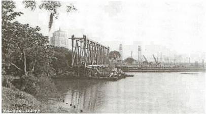
Beaumont Railroad Bridge-1941
This bridge was built in 1935. The building in the background is the Jefferson County Courthouse built in 1932. It was the KCS/MP life bridge and there was also a SouPac lift that was tom down with it traffic moved to the KCS/MP bridge. The trees to the left in this photo used to be on Goat Island, but in 1955 this area was filled in with dirt and
rip rap (Block, 2008).
Presently the Sabine-Neches Waterway is spanned by a thirty-five year old bascule-type bridge that is inadequate for, and extremely hazardous to, modem navigation. Additionally, the Waterway is too shallow and too narrow to accommodate the current heavy water traffic. To rectify both inadequacies, Congress in 1962 authorized and approved the Sabine-Neches Waterway Project (River and Harbor Act, 1962). In an effort to better not only navigability of the Waterway, but also passage for persons and vehicles over the Waterway, the Project calls for improvement of the Waterway, destruction of the old bridge, and construction of a new bridge. (385F, 1966)
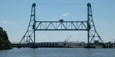
Currently existing Neches River lift bridge in downtown Beaumont:
Neches River Steamboats:
When you think of a Neches River steamboat in the 1800, you probably do not think of television's popular "Love Boat." It is a fact, however, that many Beaumont lovers found many romantic moments aboard the Laura or Neches Belle, early steamboats on the river. Hardnosed Captain Andrew Smyth of Bevilport probably saw romance blossom more than once on the steamer Laura (Block, 1995).
During 1850-1900, Cotton freight was largely carried on the Neches River between the months of December and May when the upstream water levels were high (Block, 1995). The off-season provide a time for steamboats to be tied up in Beaumont and engaged in excursion trips or hauling freight to Galveston.
Excursion voyages were a boon to steamboat owners. They provided employment for crews. Texas frontiersmen also worked hard and played hard. No other facility offered better accommodations for relaxation, dining, and dancing than the boats with provided a bar, musicians, and space for dancing (Block, 1995).
Steam boating's golden age only lasted until the Civil War on the Brazos River and until the 1873 on the Trinity. The lumber industry and late arrivals of the railroads kept steam boating on the Neches and Sabine Rivers going until 1900. A few excursion boats lasted through the early 1900s.
Looking back, it is hard to believe some of the great inland distances steamers ran. 135Łfoot boats are documented as traveling to Longview, Texas. In 1851 the iron steamship Liberty navigated the Sabine all the way to Fredonia.
Steamboats traveled the Sabine and Trinity rivers by 1838. The first record of a Neches River voyage was in 1846 when the Angelina, build at Pattonia, began cotton-carrying trips to Sabine Pass. In 1840, Robert Patton began shipping cotton from Nacogdoches to Sabine Lake by keelboat, the TL Rusk. During the 1850s, the Neches River route reduced shipping costs to $3.50 a bale, less than half of the overland wagon route to the Red River at Natchitoches, Louisiana (Block, 1995).
Two of the largest steamboats were the 1800-bale Josiah H. Bell and the 220- foot Florilda that ferried iron rails, crossties, locomotives, locomotives, box cans and construction materials along the river. Both of these boats later served the Confederacy with distinction. The Neches River cotton trade revived after the Civil War. One boat, the Albert Gallatin, was built on the banks of Brake's Bayou at Beaumont. These later boats were packets and the Graham was able to travel Beaumont to Sabine Pass in 4.5 hours.
A well-known steamboat on the Neches starting in 1872 was the Laura. This story can be found in the book, Texas Riverman written by Dr. William Seale in Beaumont. It talks of Captain Smyth and his profitable ventures along the river. Smyth died of a stroke on the Laura while docked in Beaumont in 1879 and he was buried in the Magnolia Cemetery. The Laura sank in the Neches at Beaumont two years later and was never raised (Seale, 1966).
Floating logs in the river making river traffic uncertain and the availability of the railroad for shipping cotton lessoned the importance of the steamboat throughout southeast Texas (Block, 1995). Lumber steamers, many in the form of log tugs, continued on the Neches River for many more years. Although steamboats continued through 1910 the more efficient steam or naphtha-burning tug boats and rail transport replaced river shipping. Some say that the steamboat never did disappear, they simply evolved to long tows of lumber of barges on the river and later the diesel tows of petroleum barges that continue on the Neches.
Yocum
The Yocum family dates back to misdeeds along the Mississippi River. They eventually worked their way into the Big ThicketŚmany settling in Liberty county area. Thomas Yocum saw East Texas through the eyes of a vulture. He built a country tavern in what is now the small country of Westbury near Pine Island Bayou between Beaumont and Sour Lake. The inn was in a pecan grove near the Old Spanish Trail at that time called the Atascosito Trail. This was an important trail for cattle going to New Orleans. When he heard the cattle approaching he would ride out to meet the cowboys with a friend smile and offer of accommodations. Many times he would also send his step daughter out to lure the men to his inn. Guests were treated with fine food, good conversation, fun, and a good bed all at a reasonable cost. All were invited to stop on their return for selling their cattle in New Orleans. Folks started to be suspicious after man after man started disappearing on their return trips. Also, large American horses seemed to increase in number around the Yocum place contrasting to the small Spanish horses used in the area. Even members of the Texas army were warned to be on the lookout for a man named Yocum around Pine Island Bayou. Citizens finally got tired of Yocum but he escaped before they burned his house to the ground and sent his family away. He was finally caught in Spring. All this was thought to be the work of the RegulatorsŚcitizens of East Texas wanting to end the lawlessness (Landrey, 1976). Creek in Montgomery County and was shot shortly thereafter. His son Christopher was thought to be one of the better members of the family and tried to return. Although taken into protective custody in Beaumont, he was hung in his cell with a nail through his head
Beaumont Salt Water Barrier
Because of the Neches River's closeness to the Gulf of Mexico and its 40 foot dredgedŁ depth to support area ports, salt water has a relatively unimpeded avenue for upstream movement of Gulf salt water.
Jefferson, Hardin, and Tyler Counties' Lower Neches Valley Authority (LNV A) distributes fresh water to municipal, industrial and agricultural water consumers through its five major pumping plants and 400 miles of canals. The Beaumont-Port Arthur complex is one of the world's largest petroleum and petrochemical centers with more than 26 industries employing a large portion of the local workforce and using 45% of the LNV A's water. There are no other reliable sources of water for this industry and these companies cannot accept water with more than 150 PPM of chloride and/or 250 PPM for cooling. This factor all but eliminates extensive use of local ground water to meet needs. Resin production requires high quality and this are produces about 70% of the resins used for plastic made in the United States (Chowdhury, Lacewell, McCauley, and Freeman, 1997)
During 1934-1993, the saltwater barrier was installed in 26 of the years for periods ranging from 4 to 255 days. Prior to the BSW Barrier's construction a study was done by Chowdhury, Lacemell, McCauley and Freeman that projected an average industrial benefit of $140.7 million over 50 years. A permanent barriers cost was estimated at $74.7 million by the U.S. Army Corps of Engineers showing a clear benefit Chowdhury et aI. 1997.
Reference List
385 F.2d 944, Levingston Shipbuilding Company, Appellant, v. The Honorable Stephen Ailes, Secretary of the Army, it aI., Appellees. No. 22913. United States Court of Appeals Fifth Circuit. April 15, 1966, Rehearing Denied June 17, 1966.
An analysis of Texas Waterways: A report on the physical Characteristics of Rivers, Streams, and Bayous in Texas. (1974). Prepared by Texas Parks and Wildlife Department. The Texas Agricultural Extension Service. Texas A&M University System. Prepared by: Texas Parks and Wildlife Department. Retrieved June 27, 2009: http://www.tpwd.state.tx.us/publications/pwdpubs/pwd_rp_t3200_1047/index.phtml
Block, W.T. (2009) The Opelousas Trail: Bellowing Cows Marked First
Trail To New Orleans. Retrieved June 8, 2009,
http://www.wtblock.com/wtblockjr/opelousa.htm.
Reprinted from Beaumont Enterprise, about 1975, exact date
unknown also in Block, Frontier Tales of The
Texas-Louisiana Borderlands, MSS, pp. 153-158,
in Lamar and Tyrrell libraries.
Block, W.T. (2006). Southeast Texas Stories. Retrieved March 26,2008, http://www.texasescapes.com/WTBlock/WTBlock-J r- East - Texas- History Louisiana- History.htm
Block, W.T. (1995). Cotton Bales, Keelboats and Sternwheelers: A History of the Sabine
River and Trinity River Cotton Trades, 1837-1900. Oakdale, LA: Dogwood Press.
Chowdhury, M., Lacewell, R., McCauley, G., & Freeman, R. (1997, July 13-16).
Industrial Benefits of Controlling Saltwater Intrusion in the Neches River. Presented at Western Agricultural Economics Association 1997 Annual Meeting at Reno/Sparks, Nevada.
Donovan, R. (2007, February 22). Neches River has storied history. Lufkin Daily News, p.l.
Landry. W. (1976). Outlaws in the Big Thicket (Fifth Ed). Austin:
Eakin Press.
River and Harbor Act of 1962, 76 Stat. 1173, 1175.
Rienstra, E.W. and Linsley, J.W. (2003). Historic Beaumont: An
Illustrated History. Historical Publishing Network, A
Division of Lammert Publications, Inc. San Antonio, Texas.
Seale, W. (1966). Texas Riverman: The Life and Times of Captain Andrew
Smyth. Austin University of Texas Press.